This article was updated on june 1, 2022 to reflect the new rule that bonfires are no longer allowed at KVI.
When I think of KVI beach, my mind fills with happy memories just as the tidal salt marsh floods at each high tide. Imagine the number of hours we, as an island community, have spent at KVI.
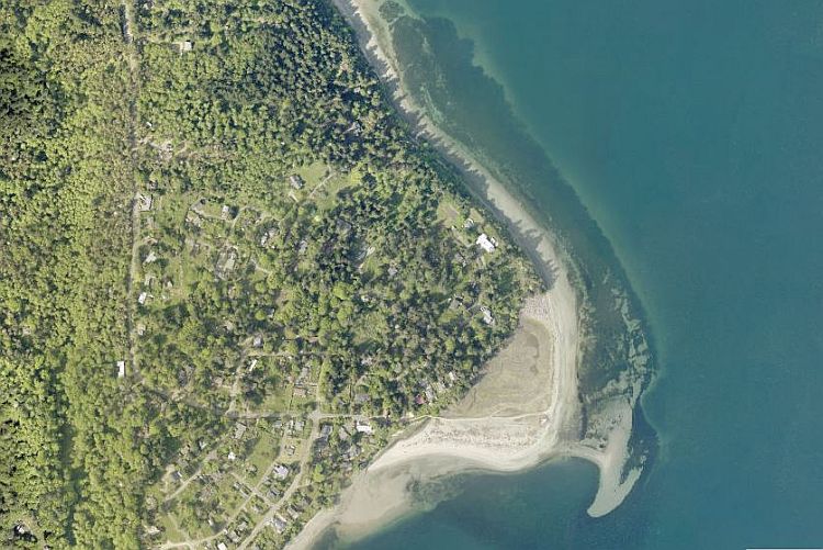
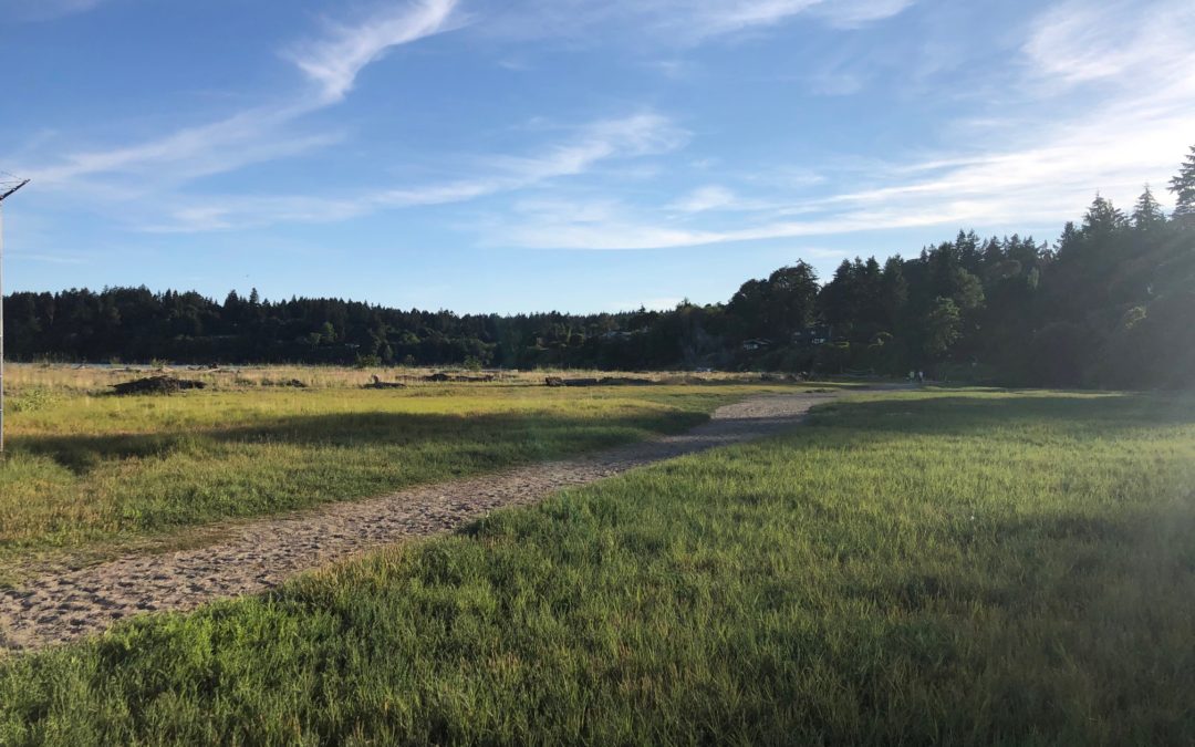
KVI is a unique gem, attracting many of us to its shoreline as well as a massive diversity of wildlife who are dependent upon this rare ecosystem. South prevailing water currents called drift cells carry sand from the cliffs to the north which maintains and builds the sand spit. This whole system contains an incredible variety of important habitats–78 acres of waterfront, a ¾ mile long sandspit beach on one side of the point, a high bluff backed gravel beach on the other, and the largest remaining salt marsh in the central Puget Sound.
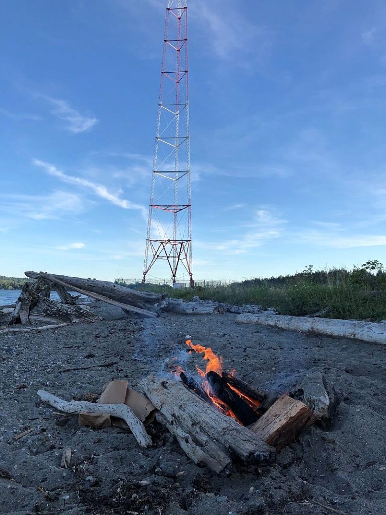
There is something about that 750 foot radio tower that captivates me as well. Installed by the KVI Radio in 1936 and then purchased by Sinclair Broadcast Group a few years ago, it continues to transmit programming while also receiving perched bald eagles and osprey awaiting their next meal. If it were not for this tower we would call this place Point Heyer, as it is labeled on maps and charts. The private ownership with allowed public access is another reason why this community asset is a rarity and vanishing type of place.
At KVI beach, no parks district employee shows up at dusk to lock a gate. Visitors are allowed to come and go whenever we please. Birders arrive at the wee hours of the morning hoping to catch sight of rare migratory birds drawn to the salt marsh, or nesting cliff birds in the bluffs. A revolving stream of canines arrive with their human companions throughout the day and year. Summertime brings families with young children, teenagers unwinding from their daily grinds, and gatherings of folks playing music and enjoying themselves as the evening skies darken and the stars come alive. Day in and day out, night after night, we come and we go. Some leaving flip flops or sand buckets, others dog poop, or cigarette butts, some burning bonfires which are not allowed at KVI. Others leave only footprints.
We visit. We visit over and over. I first began exploring beaches of the Puget Sound as a young child with my father who stressed to me I must always leave a place better than I found it. That is not always so simple. Sometimes I just don’t know that I am doing harm, if I don’t take time to think deeply about the things around me. It helps to remember when I am in nature, I am a visitor in another’s home. As part of nature myself, I have an intrinsic drive to explore and observe with curiosity.

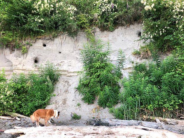
My curiosity led me to study what makes KVI so special. It is privately owned while allowing public access. (I mean, where else does that happen?) 73% of Puget Sound salt marshes have disappeared since 1890, most of which were filled for human development, a trend seen worldwide. Evidence of a vanished coastal salt marsh can be found at another famously popular beach and the nearest point just to the south – Point Robinson. In 1894, The U.S. Coast Guard upgraded the original fog signal to a new light tower. A bulkhead was constructed to retain freshwater for the stream fog signal, effectively choking the marsh of its freshwater source. Later, in 1915, what remained of the Point Robinson salt marsh was filled to stabilize the land for construction of the lighthouse. The hillside behind the lighthouse was sluiced down and today the lawn and meadow behind the lighthouse stand where there was once a now vanishing ecosystem.
A remaining similarity between KVI and Point Robinson is the incredible large driftwood amassed along the shores of both points. Large logs wash down in winter storms from the banks of the Puyallup River and fall down from the bluffs above. This results in beaches littered in downed wood stretching along the upper reaches of the beach, and at times reaching way down the beach towards the water’s edge.
Scientists who study driftwood refer to it as large woody debris. While these trees may be dead, they continue to provide a whole host of important services and benefits. Driftwood stabilizes shoreline sediment and aids in reducing the erosional effects of large storms and high tides. Insects living on and around the driftwood provide a valuable prey source for juvenile salmon and other small fish. At high tide, the water is shaded by the downed wood and small fish are able to find refuge among the tangle of logs and branches inaccessible by larger predators. At low tide the shade remains critical in keeping shoreline sediment cool and wet aiding the survival of forage fish eggs laid among the grains of sand. Driftwood, like salt marshes, is much less common along Puget Sound (and island) beaches than it was in 1890. Shoreline armoring, or structures built to reduce the impacts of shoreline erosion, eliminates upper and back beach areas where driftwood anchors. With each high tide, the logs are lifted and carried away from the armored shoreline. Check it out next time you walk on the beach. How different is the driftwood accumulation on natural beaches with connectivity to the upland terrestrial ecosystems compared to a neighboring bulkheaded beach?
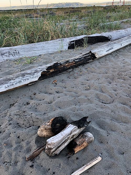
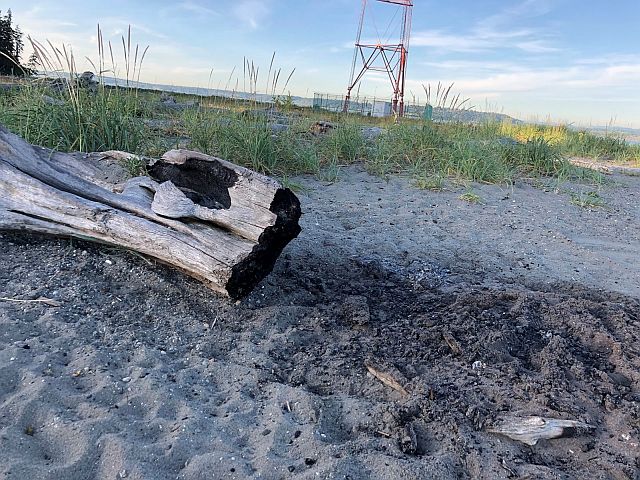
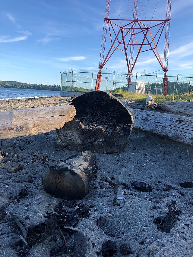
Driftwood does not just serve an ecological function for the nearshore environment, people love driftwood too. Personally, it is the perfect nook among the driftwood I seek out when I head to the beach to relax. My children (and many of all ages) play “the sand is lava” as they see how far one can run along the logs before falling off. It can be quite a long run at both KVI and Point Robinson. At the latter beach, one’s course may be cut off by a massive driftwood fort, or, if you make it all the way to the point, you may be halted by the sudden onset of scorched wood. Two years ago, a 300 foot stretch of beach line at Point Robinson caught ablaze before fire crews could put it out. The damaged, blackened wood serves as a visual reminder of the responsibility we all share in caring for our open spaces.
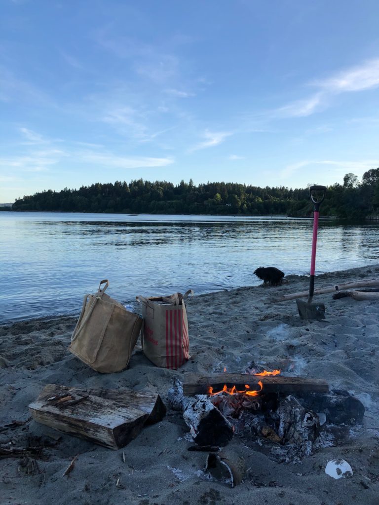
As the fourth of July nears, and our weather becomes increasingly dry it is our responsibility to do our part in caring for the island and all it offers to our community of human and other than human residents. Keep in mind that recreational fires are now banned at KVI but remember to be respectful in other places where beach bonfires are allowed, by following these guidelines:
Best Beach Bonfire Behavior
- Bring your own wood and leave the driftwood for the beach
- Do not use large diameter driftwood as windblocking or backing to your burns
- Bring a shovel to extinguish your fire and bury the charred remains
- Bring a bucket too so you can douse the smoldering wood
- Keep fires under three feet in diameter
Photo credit: header photo–Maria Metler; first photo–courtesy King County iMap; all others photos–Maria Metler. Correction 6/30/2020–KVI beach, formerly known as Bathing beach in the 1880’s and 90’s was purchased first by KVI Radio in 1936. Sinclair Broadcasting, the current owner, purchased the property only a few years ago. Thanks to Bruce Haulman for the correction.
I was just at kvi this morning wondering about the sAlt marsh – though i didnt know what it was! I also didnt know the role driftwood played in the ecosyStem. Thanks for sUch and informAtive email.
Wonderful article. So very informative. I recommend trying to have it published in the beachcomber. For me it offers valuable new information .
I agree with Sheila that this should be published in the Beachcomber. We love Kvi beach!
Thanks Maria, I learned so much from this post. I will enjoy this beach and every other beach with a new perspective.
I agree with Sheila, it should be published in the Beachcomber and maybe in the school newspaper
Wonderful.
Is there any effort being made to restore the salt marsh at Pt Robinson?
Very INFORMATIVE article. I learned so much about beach life and ecosystems. So very proud of our daughter, Maria and the EXCELLENT work she does.
Maria,
This is such a beautifully written article. I wish we could have a lovely sign with your best beach practices right by the parking, as a reminder to all who come to enjoy KVI (in addition to this article published in the Beachcomber). I might know some 5th graders up to the task :).
I think I’d want to also include some reminders to dog owners (I am one). I try to let my dog love the place in the early am and later in the evening, yet the birds do not appreciate her and I never appreciate seeing dog poop there. Of course, this goes along with your dad’s teachings to leave a place better than we find it, yet it seems we sometimes forget (and maybe we need reminders about a dog’s impact on the inhabitants there too).
Thanks SO MUCH for writing this piece!
Jen
KVI is so much a part of our kids growing up experience here. It is’nt summer without long outings there. Wonderful article, thanks. I learned so much.
Thank you Maria! Good information! I agree with folks that say it would be great to have your guidelines to beACH FIRES ON A SIGN NEAR THE BEACH ENTRANCE.
aLSO, TIPS FOR DOG WALKERS LIKE ME. . . lIKE BRING POOP BAGS AND REMOVE POOP FROM THE BEACH BECAUSE IT’S A WATER AND BEACH CONTAMINANT. aND KEEP YOUR DOGS FROM RUNNING INTO THE INTERIOR OF THE SALT MARSH WHERE WILD BIRDS ARE RESTING AND FEEDING, ESPECIALLY IN SPRING AND FALL DURING MIGRATION SEASON.
eSTELLA lEOPOLD CAME TO kvi bEACH DURING A “WALK ON THE WILD SIDE” PROGRAM IN THE 1990S AND REMARKED THAT THE HUGE LOGS AND ROOTBALLS STILL PRESENT THEN WERE A VANISHING BEACH HABITAT, LEFT FROM THE OLD DAYS WHEN FORESTED SHORELINES BROUGHT DOWN WHOLE TREES EVERY WINTER, AND THEN FOR A FEW DECADES BIG LOGS ESCAPED FROM LOG BOOMS BEING HAULED TO MILLS. 25 YEARS LATER i SEE HOW MUCH SMALLER AND FEWER THE LOGS ARE.
Thanks for the historical perspective, Rayna!
Isn’t the sand from kvi taken from the Hawaiian islands? This type of sand is not natural to the environment around the puget sound.
Someone told me this but that’s just how Vashon is….
Is this True? Where is the sand from? I have been very curious
hi Akalei, good questions. The sand spit at KVI is fed from the erosion of the cliffs just north of KVI. The water currents, called drift cells, transport the sand southward and it builds up the spit. So, the sand comes from here!
No, it’s not true! All the sand is naturally occurring.