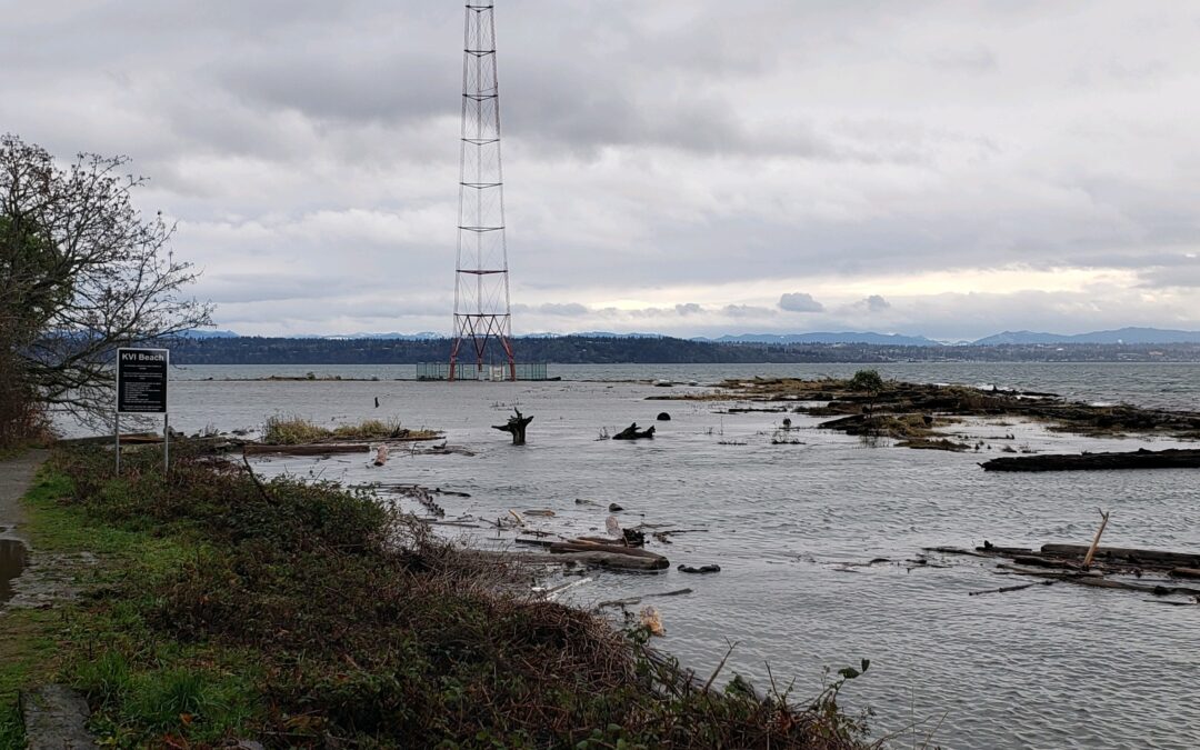
Featured Image: KVI on December 27th, 2022. Photo Credit: Island Resident
As we drove towards KVI for an afternoon walk, we hadn’t given much thought to tides. High tides just mean a shorter walk right? Most days of the year this would be a decent way to approach a walk along coastal Vashon. But not on this one.
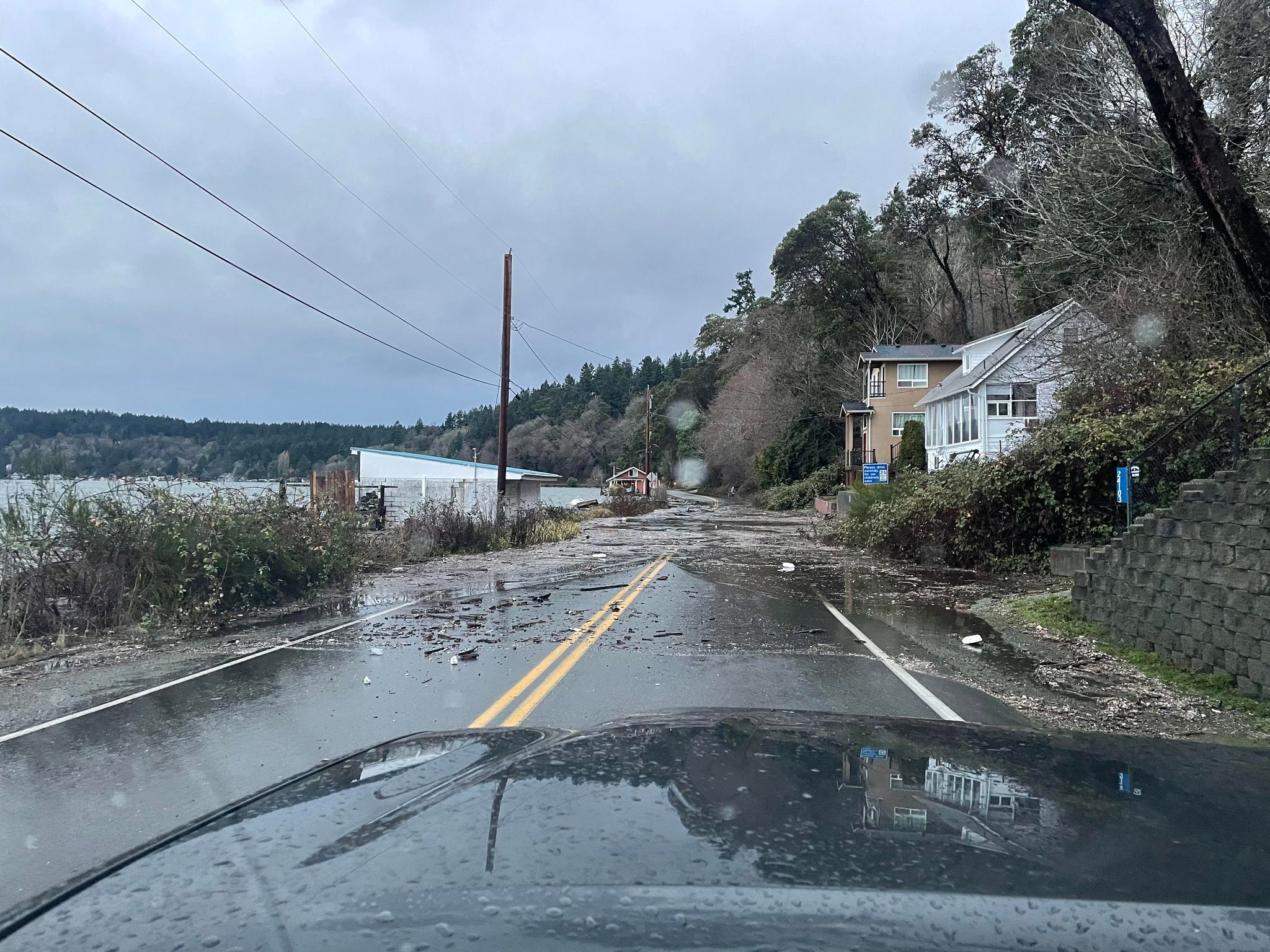
On December 27th, 2022 tides reached higher than many Vashonites remember. I dodged around a jumble of driftwood where cars normally park at Crow Beach on Tramp Harbor, ignoring the signs that I was not going to get my normal walk in. When we got to KVI, water was lapping at the legs of the radio tower and covering the bridge that spans the small channel which allows the salt marsh to drain and flood every day.
That was the end of my shoreline plans, which was disappointing but seemingly no big deal in the grand scheme of my day or even my life. But, for some people with homes or businesses near sea level across the Puget Sound it was a catastrophic event. Later that day I saw photos of other areas on Vashon and beyond, with roads along Quartermaster Harbor impassable and homes in Ellisport, and Manzanita Beach flooded.

Tides are a phenomenon that most of us who live near saltwater know and expect, but we might not actually understand where tides come from. Broadly speaking, tides are waves formed in reaction to the gravitational pull of the moon and the sun. They are one of the most reliable phenomena we can experience in the natural world, right along with the phases of the moon and sunrise and sunset.
As the earth rotates the vast bodies of water we call oceans react to the gravitational pull of the moon. Though weak, this force is enough to pull water towards the moon and this tidal force actually squeezes the planet enough to create a bulge of water on the side of the earth facing the moon and the side opposite it. These bulges manifest as long-period waves that we call tides and create the two high and low tides we experience each day. (If that doesn’t make sense, here are two videos that explain the phenomenon.) Of course, this is a simplistic version of the factors that go into our tidal systems. Things like weather and location also influence them.
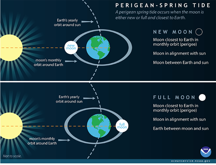
So, how do we get these extreme highs, often called “King Tides”? The setup for these events are the regular alignment of the sun, moon, and earth, which enhances the gravitational forces on our oceans. We know to expect king tides twice each lunar cycle (about a month), but not all of these events are so extreme. Where things get more intense are during “perigean spring tides,” when that sun-moon-earth alignment coincides with the moon’s perigee, the point in orbit when it’s closest to the earth. What made the December 2022 tides particularly bad was a combination of perigean tides, a low pressure system over our area, and flooding from recent weather events like the December 22/23rd ice storm.
Tides are a foundational force in marine ecosystems worldwide and humans have been using their regularity to move about the planet for as long as we’ve lived along marine shores. We rely on our shorelines as places to live and recreate, points of transit to and from our island, and as key components of the marine ecosystems that are a part of our cultural and natural heritage. As sea levels rise as a result of global climate change, king tides will have increasing and more regular impacts on our existing shorelines, properties, and roadways.
With coastal flooding and king tides on our minds, it’s easy to think about trying to reinforce our islands’ edges with concrete and boulder bulkheads. In some cases this might be the only solution to maintain existing infrastructure. However natural bluffs and shorelines are often more resilient and cheaper to maintain long term. They are also vital to our local nearshore ecosystems, habitat that directly supports juvenile salmon among many other species. The Vashon Nature Center blog has covered why natural shorelines are more resilient to the impacts of climate change and highlighted the Shore Friendly King County Program, which helps waterfront owners find solutions for managing their shorelines.
You might be feeling a bit helpless in the face of king tides and rising sea levels, but there are ways you can help understand these phenomena and motivate action on shorelines near and far. The My Coast App gives anyone the opportunity to photo document events like those of December 27th and 28th, adding them to a database that allows scientists to more accurately map tidal inundation and predict impacts of sea level rise. This national program is locally sponsored by Washington DNR, WA Sea Grant, USGS, the Northwest Straits Initiative and Snohomish County Marine Resource Committee, who all have a vested interest in healthy, climate resilient shorelines. With the My Coast App you can also report things like washed up boats or creosote debris that might otherwise be unaddressed.
We are expecting another round of extra high tides in the coming week – the mornings of January 23-25, 2023 are expected to be the highest. We might not have quite the roll out of weather that pushes the tides higher as it did last month, but it’s likely they’ll still have impacts. And while we can’t outrun things like the sun, the moon, and climate change, we can plan for a future of increasingly higher tides by making good decisions for people and place today.