written by: Mary Bruno
This is the sixth in a monthly series of guest blog posts that Mary will be sharing about island water quality topics thru the Groundwater Protection Committee.
Tom Dean has been the Executive Director of the Vashon-Maury Island Land Trust since August 2003. In his 17-year tenure, the Land Trust raised millions of dollars, preserved 2,200 acres, built miles of trails and bought a farm—Matsuda, its first ag-quisition. Dean’s time as Executive Director ended this year when he became the Land Trust’s first Conservation Director. The new role suits his unique skill set. Dean grew up in Burns, Oregon. He majored in English at the University of Oregon where he once heard beat poet Allen Ginsberg recite Howl. He has fought rangeland wildfires, edited for Microsoft, baked bread at La Panzanella, restored salmon habitat along the Duwamish River, and raised money for People for Puget Sound. Most importantly, he is able to straddle the realms of “what if” and “here’s how.” As Conservation Director, Dean will scout out land to buy, find a way to buy it, and construct a network of trails that knits the Land Trust holdings together. I talked with Tom about his vision for the Land Trust, about beavers and fire and sea level rise, and about the importance of preserving forests as a way to protect the water beneath them.
[Note: My questions appear in bold.]
What is the role of the Land Trust, and has its role changed?
“We started as a wildlife habitat conservation organization and we have been successful with our [conservation] goals, such as sustaining wild spawning runs of Coho salmon in Judd Creek and Shinglemill Creek. My vision for the Land Trust is to do more for the community as a whole. How can we use our knowledge of the land to help the community? When I came on, I wanted to make our properties more accessible to the public. Trails provide an important avenue for people to re-connect with nature. It is only through our connections to the land that we can solve problems like climate change. Five years ago, we started our first farm conservation project with Matsuda Farm. Today, we are demonstrating how farmers can practice ‘regenerative farming’—carbon-positive and habitat-positive—while providing the community with healthier food and building a stronger local economy.”
Does the Land Trust consider groundwater when it targets land to purchase?
“[The groundwater benefit] has been more accidental, partly because a lot of the highest recharge soils happen to be in super sensitive areas that we’re interested in, like shorelines and streams. Recharge is based on soil permeability. Sandy soils are high recharge [because water percolates easily through them]. Glacial till [which is mostly clay] is low recharge, because it just holds the water up on the surface. If you go into iMap you can pull up this three-color map that shows the location of recharge soils on the Island. And you’ll see patterns: high recharge soils follow the paths of rivers, surround pond areas in the middle of the Island, and follow the shoreline. The projects we’ve done that have the most high recharge soils have been Fisher Pond and Island Center Forest—both are high, perched wetland areas that don’t have glacial till underneath them—and Judd Creek. Beyond that, it’s been a lot of the shoreline work we’ve done with King County.”
Are there any high recharge areas on the Island that you’d like to acquire?
“I’d have to do more study to answer that question. Some high recharge areas are in places that are already developed, so there’s nothing we can do about those. But there’s a very, very large wetland south of Cemetery Road, the largest wetland on Vashon. It has a lot of high recharge soil and is largely unprotected. One of our basin stewards did a survey and counted 11 or more springs coming out of the hillside south of that wetland. That’s a lot. I’d probably point to that spot first.”
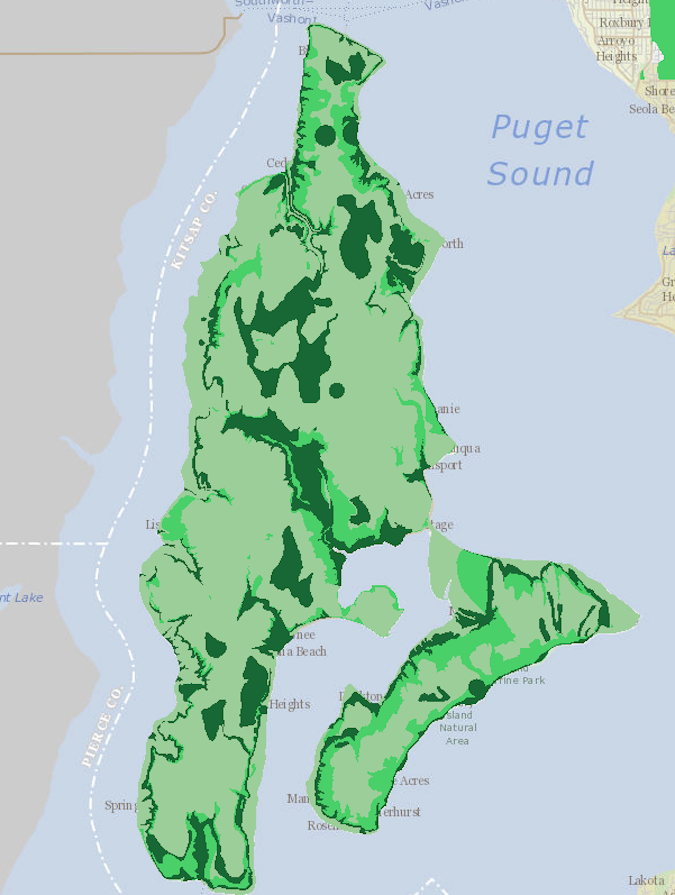
the paths of streams, surround mid-Island ponds, and trace the shoreline (medium green).
Source: King County iMap
You mentioned recharge areas that are already developed. Where are they located?
“A good example is the area around Burton Hill into a little bit of Misty Isle Farm. That whole area is high recharge and it’s all built out. Not awful. Not like suburbia. But there’s very little opportunity to set aside land there other than perhaps that part of Misty Isle that has been pesky for water quality for Burton Water.”
I don’t think of Burton Hill as that developed? It’s not like residents are paving over their property.
“But what if there was forest there? What if it was completely forested? I think of forests as part of the structure of the aquifer. We tend to draw a line between the two, but nature doesn’t draw lines. Because when rain falls, even if a place is lightly developed, it’s running off roofs, driveways, roads, pastures. That’s all running off into Puget Sound, right? When you have a forest, the structure of the forest holds that rain in place and lets it percolate down into the aquifer. This is important because climate change does two things here: It increases the threat of wildfire—which we’ve seen recently—so you can lose your forest; and it concentrates rainfall in these heavier events in the winter, the so-called atmospheric rivers. Rain falls harder and faster. That makes the slowing action of the forest structure all the more important.
“Part of what the Land Trust is doing is trying to save forests, period. But a lot of focus for us is on large tracts of forest. And there’s another climate change factor with forests. Doug Firs in particular, when they get to be 80 years old, their growth slows. That means they’re transpiring less. They are more resilient to those long hot summers that are also being brought on by climate change.
“So saving forests matters. And saving old forests matters more.”
What are the greatest threats to our local land and water?
“Let’s talk about sea level rise. People who live on the shoreline: where do they get their drinking water? By and large these little shoreline neighborhoods either have a small [well] system or their own spring. It’s all locally sourced water. My question regarding sea level rise is what happens first? Are you driven out by a big wave that crashes through your front window, or by saltwater in your drinking water supply? It’s probably a different analysis for every little neighborhood. But one of the things I’ve been working on is the King County Flood Control District. We all pay into it, but the District doesn’t have a flood control program for Vashon. I know they’re thinking about it. They’re starting to talk about it. But in general it would be nice if the Flood Control District had some sort of [saltwater] buyout program for Vashon. My fear, like with development, is that the shoreline properties will be so valuable that people will build giant sea walls.”
Maybe, but a seawall won’t protect your drinking water.
“True. As much as people don’t like to think about it I think there will, at least in certain neighborhoods, have to be a retreat from the shoreline.”
Is fire a threat to our drinking water supply?
“I have never been a fire alarmist. And then we had that Red Flag event last September where any spark could have set off an awful fire. There were tree limbs snapping right and left in that wind on Labor Day, hitting power lines. We had a fire on South Maury that started that way but they caught it.
“Cliff Mass says that climate change may actually weaken the strong easterly winds that contributed to that Red Flag event. But that doesn’t mean we won’t get them. And we’re still looking at hotter, drier summers. Should we take steps to prevent a catastrophic fire that could wipe out forests above our aquifer? Would it make sense for Vashon to ask Puget Sound Energy to black us out when we get a Red Flag Warning? Do you sacrifice the food in your refrigerator to save your drinking water? Do you do the work to make sure that everyone who needs a generator to literally stay alive has one? Do you set your community up emotionally so it can handle that kind of situation? I know that this is four or five steps removed from groundwater protection, and that it’s practically impossible to get a whole community to agree on a voluntary blackout. But that’s the kind of problem that climate change puts in our face.”
Does development threaten the water supply?
“The economics of doing development outside the Vashon Town Core are really bad, because you have to build a lot of infrastructure. We’re not a city that has a lot of roads and sewers and power lines and stuff like that already laid. The Land Trust is trying to buy up the biggest pieces that are left as fast as we can before that changes.”
Tying up land on an island can have negative consequences, like the loss of housing stock. Do you worry that Land Trust acquisitions threaten the affordable housing market?
“No. We buy either wetland that nobody can build on very easily, or big tracts that would support very, very expensive single-family housing. We’re buying the gentrification pieces not the worker or low-income housing pieces. But housing is something I worry about. Part of the reason the Town Core doesn’t get more housing is because there are so many wetlands sitting up there. Some of them are very low functioning wetlands and this is where the broad brush of environmental regulation doesn’t work very well for us here. I would prefer to see some of those wet areas in the Town Core actually filled and developed for worker housing and lower-income housing, and see the mitigation money spent on something that would improve aquifer recharge.”
What kinds of projects could improve recharge?
“Fake beaver dams. You build the dam without the beaver. If you look at the upper parts of Shinglemill and Judd Creek there are excellent opportunities to pool up water and that has two benefits: One is you slow the flash, which improves salmon habitat. The second is, theoretically, you get more aquifer recharge out of those beaver ponds.”
People seem to be more savvy (and worried) about water these days. Does that make you hopeful?
“People are talking more about water scarcity. The water conversation is really broadening in the press. If you’re in Seattle you can point at the reservoirs and say, ‘That’s where our water comes from.’ It’s harder on Vashon because you can’t see the water. And we do take it for granted as a community. Whether we have enough water is not quite as important as do we really care? And do we care enough to do what’s necessary to protect it?”
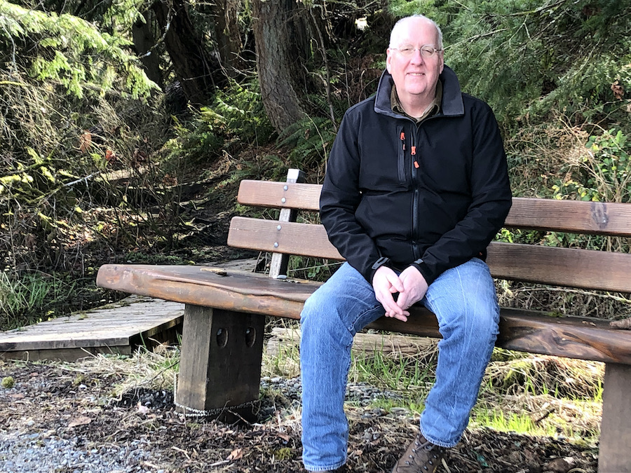
Feature photo: To Land Trust Conservation Director Tom Dean, forests are an integral part of the aquifer. “We tend to draw a line between the two, but nature doesn’t draw lines.” Photo by: Mary Bruno
I applaud the Land Trust for seeing and acting on a bigger picture that includes farms.
On the salmon conservation goal.
I speak as one who has been involved in salmon monitoring, testing, and restoration efforts on Vashon for over 20 years.
Many thousands of dollars have been spent and many thousands of volunteer hours have gone into dropping logs into streams, purchasing land adjacent to streams, planting trees and shrubs, invertebrate sampling, educating homeowners on stream friendly practices, and much more.
But unfortunately we still don’t have a lot to show for it.
Vashon Nature Center has the actual numbers from their volunteer salmon watcher program which I have participated in before they existed and up until a few years ago.
But the numbers are very low, for Judd and Shinglemill usually less than 50 salmon per year in each stream.
The elephant in the room that few want to address is salmon fishing at the mouth of Shinglemill and Judd and offshore, but most especially fishing in Colvos Passage in the Fall by commercial fishermen.
Have you ever seen that? I have when I lived on Sylvan Beach. It was pretty obvious to me that it would be very difficult for salmon to make it past the gauntlet of multiple commercial nets to Shinglemill and other streams.
I asked a Washington Department of Fish and Wildlife employee and a King County employee whether fishing limits near Vashon were set based on returns to Vashon streams and I was told no. They are set based on returns to the large rivers mostly on the mainland. I was told that we on Vashon could change that if we carried out a major campaign on the island and got a large segment of the population to support setting the fishing regulations based on returns to Vashon streams. And of course that would require work with the state legislature to pass new regulations. But I think that would likely lead to little to no fishing near Vashon for a number of years until the numbers returned to a more sustainable level. And maybe no more commercial fishing in Colvos Passage.
I am a fisherman and have nothing against recreational or commercial fishermen.
Recharge of the aquifer.
The best recharge areas are not just where the soils are permeable.
They are also based on the geology below the soil.
Recharge is only possible in areas where water can make it through the rocks below ground. Either through openings and cracks or because of the permeability of the rock. The excellent water book “Water in Environmental Planning” by Thomas Dunne and Luna Leopold has a lot to say on this.
Related to recharge Tom focused mostly on developed versus forested land.
But there is on site stormwater control which is basically a whole toolbox of methods for slowing, spreading, using, and sinking stormwater on site.
Rain gardens, rainwater systems, permeable pavement, swales, porous asphalt, and more.
Diane Emerson and I have worked with a number of clients through the King County Waterworks program. And in that program we have showed them many ways to help infiltrate and control their stormwater on site.
And let’s not forget that for homes on septic systems a lot of their water does infiltrate into the ground.
That said forests are great at helping infiltrate water, but even with them some of the water that comes their way evapo-transpires into the air which is not a bad thing.
Sea level rise
I agree with some of Tom’s comments about how as the ocean starts rising more, shore based water systems will get saltwater intrusion and some homes may get hit with damaging waves and many on the shore will have to retreat soon.
I am not real excited about taking on the very expensive cost to help everyone move who has property endangered by the rising ocean. That will be a huge cost. Can we all afford that?
This is a tough question that will start being addressed all around the country.
The cost of buying out all the at risk properties nationwide would be staggering.
On the fire threat.
Instead of helping people get generators that run on fossil fuels we should be helping them look at non-fossil fuel options like getting battery storage systems like the Tesla wall packs that do not require fossil fuel use.
Does development threaten the water supply?
I have been watching the results every year for over 20 years of King County staff annual report OF THEIR MONITORING OF WELLS ON VASHON.
CONTRARY TO WHAT some say, those reports have consistently shown that there is no evidence that we are anywhere close to running out of water.
That said I do not want to see a lot more development here and I have made a large personal investment to reduce further development in a particular forested area on vashon.
But I think those of us who want to limit development on Vashon should do so through the king county planning process. And we should try to make use of the best available science to back up our assertions.
I disagree with Tom that buying up land has no impact on affordable housing. I Speak as one who wants to see more affordable housing on vashon and as one who bought up some land that could have been used for housing.
Affordable housing exists and could exist anywhere on Vashon, not just multi-family structures in the downtown area where the climate impact would often be less, but in what used to be called mother in law apartments above garages, backyard cottages, basement apartments and more.
I agree with Tom on his suggestion that King County should be encouraged to be more flexible in allowing some development in wetland areas near town if it can be done by setting stringent requirements to restore an equal or ideally greater amount of wetlnd and if it sets tought ongoing guidelines to ensure that the restoration is continued indefinitely.
And I think the artificial beaver dams are a great idea and for that matter bringing back some real beavers would be great if it can be done in a way that is legal and minimizes unintended negative consequences. https://your.kingcounty.gov/dnrp/library/2018/kcr2992/kcr2992.pdf.
Thanks To Mary and Tom for the good interview questions and answers.
All the best.
I found both Tom”s and Michael’s comments about water, climate change, and housing very good. I’m concerned about affordable housing as well and agree with Michael that it would be better to locate much of it outside of the town of Vashon. In addition to Michael’s suggestions, I would suggest that we consider densifying tradtional villages centers such as Burton, Docton, Tahlequah, Colvos, etc. given that the natural processes in any given area aren’t compromised. These areas could add small commercial land use to obviate our dependence on the town of Vashon and reduce the amount of driving we need to do.
I applaud the Land Trust for seeing and acting on a bigger picture understanding about land protection and restoration that includes farming.
On the salmon conservation goal.
I speak as one who has been involved in salmon monitoring, testing, and restoration efforts on Vashon for over 20 years.
Many thousands of dollars have been spent and many thousands of volunteer hours have gone into dropping logs into streams, purchasing land adjacent to streams, planting trees and shrubs, invertebrate sampling, educating homeowners on stream friendly practices, and much more.
But unfortunately we have very little to show for our major effort.
Vashon Nature Center has the actual numbers from their volunteer salmon watcher program which I have participated in before they existed and up until a few years ago.
But the numbers are very low, for Judd and Shinglemill usually less than 50 salmon per year in each stream. It makes me sad to have seen this minimal progress. I think it is long past time to look at additional efforts to restore the salmon.
The elephant in the room that few want to address is salmon fishing at the mouth of Shinglemill and Judd and offshore, but most especially fishing in Colvos Passage in the Fall by commercial fishermen.
Have you ever seen that? I have when I lived on Sylvan Beach. It was pretty obvious to me that it would be very difficult for salmon to make it past the gauntlet of multiple commercial nets to Shinglemill and other streams.
I asked a Washington Department of Fish and Wildlife employee and a King County employee whether fishing limits near Vashon were set based on returns to Vashon streams and I was told no. They are set based on returns to the large rivers mostly on the mainland. I was told that we on Vashon could change that if we carried out a major campaign on the island and got a large segment of the population to support setting the fishing regulations based on returns to Vashon streams. And of course that would require work with the state legislature to pass new regulations. But I think that would likely lead to little to no fishing near Vashon for a number of years. And maybe no more fishing in Colvos Passage.
Recharge of the aquifer.
The best recharge areas are not just where the soils are permeable.
They are also based on the geology below the soil.
Recharge is only possible in areas where water can make it through the cracks and openings in the rocks below ground or infiltrate through the rocks sometimes.
Related to recharge, Tom focused on developed versus forested land.
But there are on site stormwater controls which is basically a whole toolbox of methods for slowing, spreading, using, and sinking stormwater on site.
Rain gardens, rainwater systems, permeable pavement, swales, porous asphalt, and more.
Diane Emerson and I have worked with a number of clients on Vashon through the King County Waterworks program. And in that program we have showed them many ways to help infiltrate and control their stormwater on site.
And let’s not forget that for homes on septic systems a lot of their water does infiltrate into the ground.
That said forests are great at helping infiltrate water, but like other plants they also evapotranspire some water into the air which is not a bad thing.
Sea level rise
I agree with some of Tom’s comments about how rising sea levels will contaminate water supplies close to shorelines and how some homes will be damaged by rising seas.
I am not real excited about taking on the very expensive cost to pay for relocating all the homes in danger from rising seas on Vashon; that cost would be huge.
This is a tough question that is just starting to be addressed around the country.
The cost of buying out all the at risk properties nationwide would be staggering.
On the fire threat.
Instead of helping people get generators that run on fossil fuels we should be helping them get non-fossil fuel based back up options like battery storage systems like the Tesla wall packs that do not require fossil fuel use.
Does development threaten the water supply?
I have been watching the results every year for over 20 years of King County staff annual reporting of their regular monitoring of water levels in wells on Vashon.
And they have provided no evidence that we are anywhere close to running out of water on Vashon.
That said I do not want to see a lot more development here and I just made an investment to reduce development in my neighborhood.
But I think those of us who want to limit development on Vashon should do so through the King County planning process trying to make use of the best available science aand test results to back up our claims.
I disagree with Tom that buying up land has no impact on affordable housing. I say this as someone who bought some land that could have had development and as someone who wants to see more affordable housing on Vashon.
Affordable housing exists and could exist anywhere on Vashon, not just multi-family structures but in what used to be called mother in law apartments above garages, backyard cottages, basement apartments and more.
I agree with Tom on his suggestion that King County should be encouraged to be more flexible in allowing some development in wetland areas near town. In doing that they she set strict requirements for creating and or restoring a wetland area equal to or greater in size to the one impacted by the development. And set inspections to ensure the wetland restoration/mitigation continues into the future.
And I think the artificial beaver dams are a great idea and for that matter bringing back some real beavers would be great if it was legal and Could be done in a way that minimized negative unintended consequences. https://your.kingcounty.gov/dnrp/library/2018/kcr2992/kcr2992.pdf
Thanks for the good interview questions and answers Mary and Tom.