The Groundwater Protection Committee often gets questions about the Vashon-Maury Island aquifer. Fortunately, there are several excellent sources on the subject, which you’ll find below. But an aquifer FAQ seemed like a good idea. I turned to Eric Ferguson and Steve Bergman for expert guidance. Eric is a state-licensed geologist and hydrogeologist who, as a water quality planner with King County, has monitored groundwater on the Island since 2001. Steve spent 20-plus years as a research geologist in the Texas oil industry and a college geology professor. He’s been a “geo-activist” since retiring and moving to Vashon in 2017. They suggested that we begin with the basics:
What is an aquifer anyway?
The word is a mashup from the Latin for water (aqui) and to bear (ferre). Merriam-Webster defines an aquifer as “a water-bearing stratum of permeable rock, sand, or gravel.” The US Geological Survey (USGS) describes “a formation, group of formations, or part of a formation that contains sufficient saturated, permeable material to yield significant quantities of water to wells and springs.” We’re not talking about subterranean rivers or lakes here. Aquifers are more like wet rocks or dirt. Sponge is a common metaphor. An aquifer can be “just about any type of sediment or rock,” says Steve, as long as there’s “connected pore space.” Whatever you do, Eric begs me, “Please don’t say, ‘underground’ aquifer. There are no above ground aquifers.”
Where did our aquifers come from?
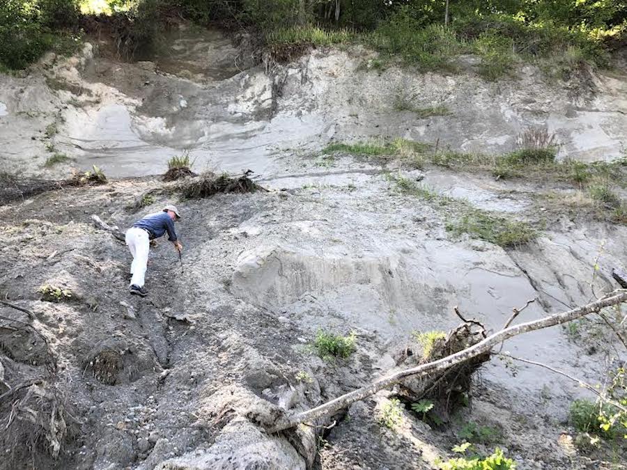
“They were deposited by continental glaciers and river systems during the last several million years,” says Steve. “Continental Ice Sheets advanced [from the North] in this area many times during the Pleistocene Epoch (2,580,000 to 11,700 years ago). The most recent advance occurred 20,000-16,000 years ago. Some of Vashon’s older and deeper aquifers were deposited during interglacial periods [when the ice retreated, leaving the land exposed]. One example is the Whidbey Formation river sands and gravels, which were deposited 80,000-125,000 years ago, and are visible in the beach bluffs on north Maury.”
[For more VMI geology, watch Steve’s Vashon Rocks! talk, and check out this detailed map from the USGS.]
Is there one, continuous aquifer on the Island, or many smaller aquifers?
The glacial/interglacial cycles that Steve described above left us with a stack of water-bearing and water-retarding formations that extends far below sea-level. “The coarse layers are typically water bearing,” says Eric. “The fine sediment layers are not.”
Coarse sands and gravels from glacial and interglacial rivers and streams make excellent aquifers. The Island’s productive Qva aquifer is a textbook example. Fine clays and silt from interglacial lake bottoms have the opposite effect. Compressed over time, their once connected pore space squeezed shut, layers of clay and silt present formidable barriers to flow. Known as aquitards, they occur on the Island in the form of hardpan and Vashon till. These formations “restrict groundwater flow due to their reduced porosity and permeability,” says Eric, and “there are many.” Indeed, till blankets most of Vashon and Maury. [Note the large green swaths of till on the Liquid Assets map below.]
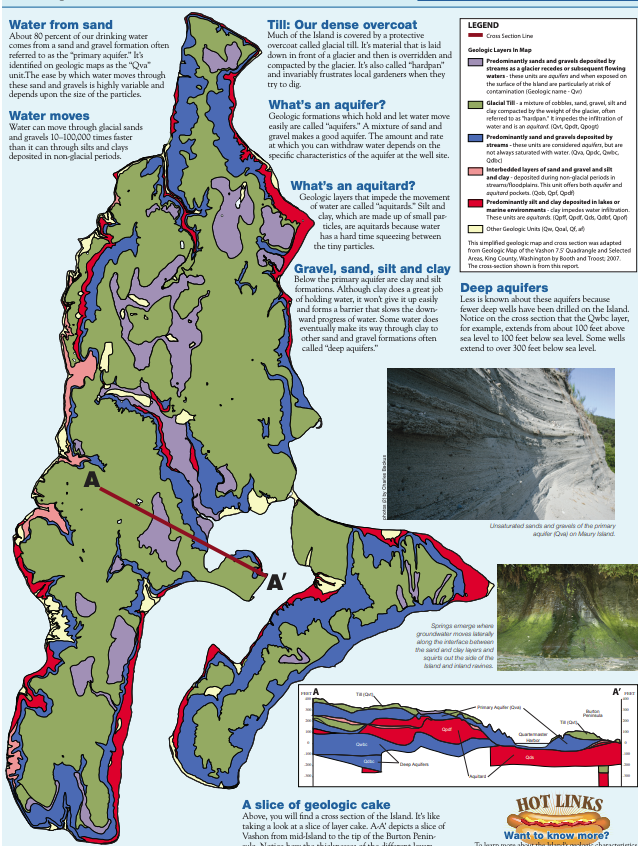
Source: Liquid Assets
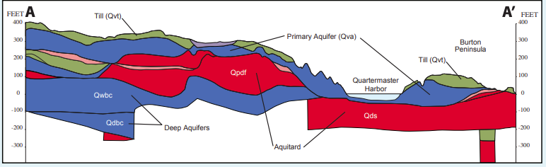
The water-bearing layers beneath the till formed during glacial times when ice sheets advanced as far south as Olympia. Most of our drinking water (about 80 percent) comes from a porous zone of sands and gravels that were dislodged from the leading edge of advancing glaciers by streams of melting ice. This slushy zone is the Vashon Advance Outwash aquifer, or Qva. Geologist J. R. Carr called it the Principal aquifer in a seminal 1983 report. “The Qva is the most widespread (mapped) unit across the Island and is highly variable in its composition,” says Eric. “A few creeks (Shinglemill and Judd) cut through this unit. There are also many aquitards. Therefore it is not continuous.” The island’s aquitards lie between and sometimes within its water-bearing zones. [The cross-section map below locates the Island’s aquifers (blue) and aquitards (red).]
The Qva isn’t our only aquifer. The similarly porous Qvr aquifer is composed of sands and gravels that were melted off receding glaciers. The so-called upper and lower coarse-grained units—the Q(a)c and Q(B)c, respectively—are older, deeper down in most places, and less understood than the Qva and Qvr. “The deeper unit(s) may be more continuous,” says Steve.“However this is highly unlikely due to the nature of the glacial and fluvial [river or stream] depositional processes that formed them. We have very limited data [about these older formations], via boreholes and surface geology, and need more study to understand our Island’s geology.”
Source: Liquid Assets
How do our aquifers behave?
Each aquifer, not just here on Vashon but everywhere, is unique. Traits such as the volume of water an aquifer can hold, the ease with which water can move into and through an aquifer, and the qualities of that water all vary with the geology. Basalt, shale, clay, sandstone, carbonate, silt, sand, gravel. “Each geologic unit has a range of values for how well it transmits water and how much water is available,” says Eric. The differences can be striking. Measured in feet per day, water moves through unfractured basalt slower than through coarse gravel—by 13 orders of magnitude!
Vashon’s loose sand and gravel layers excel at collecting and transmitting water. They can also influence water quality. An aquifer is not an inert container like, say, glass. It can actually change the water it holds. The type and degree of change depends on the aquifer’s mineral composition and its recharge rate. That’s the time it takes for water to percolate down into and refill, or recharge, an aquifer.
“Longer residence times (longer flow paths) slowly change the chemistry of the water,” says Eric. pH goes up, dissolved oxygen comes down, for example. These chemical shifts help to leach certain things out of the rock. “Iron, manganese, arsenic and hydrogen sulfide (the rotten egg smell) are a few elements or compounds dissolved in the local groundwater,” says Eric. “The aquifers derived from older glacial units typically have these components in their waters.”
Iron and sulfide are unpleasant but not unhealthy. Arsenic, which occurs naturally in deeper aquifers, is a health risk if it exceeds 10 parts per billion. Manganese is getting renewed scrutiny from the Department of Health, which may change its current just-a-nuisance categorization.
What threatens our aquifers?
“One big threat is saltwater intrusion,” says Eric. “To state the obvious, VMI is an island surrounded by saltwater. The Island has a flowing freshwater lens under and around it that keeps the saltwater out. Saltwater intrusion occurs when there’s a reduction in the volume of freshwater leaving the system and pushing out against that lens.”
A drop in freshwater pressure occurs for “three primary reasons,” says Eric.
- “Too much water is being taken out of the system due to over-pumping/over-usage; [Steve adds an additional threat from over-pumping: ‘An aquifer’s ability to hold water can be reduced by compaction and damage due to excessive water extraction.’]
- “Too little water (in the form of precipitation) is entering the system due to drought and/or climate change effects;
- “Changes are being made in recharge zones (paving, for example) that make it harder for water to infiltrate and replenish the system.”
Whatever the cause, saltwater intrusion is difficult to reverse. And it isn’t the only concern.
The truth is that we are the biggest threat to our aquifers. Most human activities interfere with water’s journey from the sky to an aquifer, or poison it along the way. Development turns permeable natural surfaces into hardscape that defies percolation. Deforestation favors runoff over seep. Fertilizers, pesticides, failing septics, leaking gas tanks, illegal dumping of wastes like recycled asphalt from roadways. The list goes on.
Our aquifers are protected in part by the impervious layer of Vashon till that drapes the island like a tarp. But the till isn’t everywhere. Recharge zones are till-free places where water can easily reach the aquifers. Sandy soils make the woodlands and pastures near Misty Isle Farm and Burton Water Company a high recharge area. High recharge zones run in a north-south line down the center of the Island, and include Fisher Pond, Judd Creek and a large patch in the Heights neighborhood. [Note the purple areas on the map above.]
Recharge zones are critical for replenishing our water supply. They are also, by their nature, extremely fragile. If water can easily percolate into the aquifer so can any contaminants it might carry with it. Beware what you dump on the ground, especially in recharge zones. It’ll wind up in your drinking water.
If you’re still thirsty for more info on our aquifers, here’s where to find it:
Natural Wonder — This cool, free Vashon Nature Center exhibit features aquifer facts, maps and a 3D aquifer model. Open 1-4 pm, Wednesday-Sunday, at Vashon Heritage Museum, through June 2023.
Protecting Our Liquid Assets — Excellent, illustrated guide to water resources from King County and the Vashon-Maury Island Groundwater Protection Committee (VMIGPC).
Assessing Our Liquid Assets — 2010 “report card” on water quality, quantity, use and management, and overall ecosystem health from King County and the VMIGP.
Water Facts: Water on The Rock — 2006 informational series from the VMIGPC.
Vashon- Maury Island Water Resources – A Retrospective of Contributions & Highlights — 2013 summary of the County’s 23-year-long program to monitor precipitation,
stream flow and groundwater.
Excellent summary Mary. I’ve been studying and tracking information on our aquifers for a few years now and I found this a great overview and I learned a bunch as well. Thanks! – Morgan
Hi Mary, I enjoyed the article but think it lacked some punch around the issue of contamination. It is often true that good soils for septic systems coincide with recharge areas. I think the danger of nitrate contamination is much greater than salt water intrusion. Aquifer levels are not dropping which tells us that the pressure from groundwater pushing out is remaining constant.
Thanks for your work.
Hi Mary
Glad to get this great overview! What I’m curious about is our capacity to reduce runoff on Vashon with the use of retention ponds, swales, and dams in ravines, for example, all with the goal of both recharging the aquifers, creating more ecosystems, as well as slowing runoff to seep into surrounding soils, where microbes can deal with toxins.
In other words, what if Vashon soils were regenerated and along with water retention, the island was turned into a great, green sponge? I know about rain gardens, and I hope they can happen soon, but those are not the only and ultimate solution, are they?
Thanks for your work!
Rondi
Your comment is awaiting moderation.
This is a very useful document. Thank you. The Quadra ICAN water security team is asking the same kinds of questions about our water as you asked about yours. Here is a link to a document we prepared on Quadra Island Groundwater and Aquifers. https://leegass.com/a-short-course-on-groundwater-and-aquifers/